Showing posts with label Laser Scanning. Show all posts

Monday, 21 January 2019

Surveying at Speed


With the progression of time the powers that be are seemingly obsessed with collecting as much data as possible in the shortest amount of time.

We'll brush over the transfer from Chain Surveys and Plane Tables onto Theodolites and Tacheometry, through handbooking of data onto on board data logging as these are gradually progressions of technology to achieve the same end goal....and geometrically accurate topographical survey.  You can argue the accuracies change, and presentation varies but the basis information remains intact.

In the mid 1980's Wham, Madonna and Simple Minds where all taking it in turns topping the charts, CD's were introduced, Coca Cola introduced New Coke, and GPS (Global Positioning System) was being made commercially available.  It wasn't until the late nineties and early noughties that Surveyors started accepting GPS as an every day essential as opposed to a very heavy luxury.  Even then the GPS wasn't used for much more than establishing site control, then monitoring and finally for surveying site detail in certain circumstances.  Then SmartNet reared it's head, and merged the growing mobile phone networks into the GPS to provide a reliable system for terrestrial land survey.

Take a look below, with the advent of GPS (Global Positioning System) and, in this instance, Leica's SmartNet.  90% of the survey shown was completed in one (long) site day by one Surveyor.  Using the SmartNET system our Surveyor was able to measure 3,500 individual points in one day to an accuracy of +/-15mm which is more than good enough for most survey requirements.  So was 3,500 points a lot, well yes when view historically at the time.  In 2000 a good days work would have been 450-500 points depending on the nature of the work (open field is quicker than a woodland, but a road is more point intensive).  By 2005/2006 this tally was closer to the 750-800 points, and then moving into 2010 anything less than 1000 points was seen as falling short....see targets everywhere but I'd rather have 500 accurate points, and a 1000 points with a higher degree of error!  By 2010 SmartNet was coming into commercial markets, and you can see the massive jump in points collected from 1000 up to 3,500-4,000.

The image below shows roughly what 4,000 points looks like, covering all the detail between the two roundabouts, and the roads to the north and south.  These we almost perfect conditions for surveying with the weather, and the network strength in our favour.


With GPS and SmartNet establishing themselves nicely the next step had started to evolve....3D laser scanning.  For the first time in Surveying evolution we were about to enter a realm of surveying too much information (if that is even possible).  Perhaps 'too much' is the wrong was to describe this.  If a total station is a sniper rifle picking up the bare minimum to reflect the ground on a 2D or 3D plan, then a laser scanner is more like a paint bomb covering everything and anything.  Recording everything within line of sight of the scanner, waiting for the Surveyor to get back to the office to trim out the superfluous data and produce the same 2D or 3D plan.  The benefits are there, if there are any queries the site has been captured in perpetuity and can be revisited to respond to any queries.  The Surveyor can spend less time on site, and can do the work from a safe (or at least safer) location without the need to get too close to the main road or cliff edge.  On the downside (for some) it means a lot more time in the office interpreting the data and developing it into a format which can be utilised by the end user.

Of course sometimes the new technologies and old methods do merge into one.  In the case below using the laser scanner (in this case a Leica C10) saved days on the site work, but this was offset by the additional office time required isolating the relevant information.  This 'sorting' of information was formally done on site using the Surveyors experience, they can survey only the relevant information.  The scanner take on a more global approach and picks up everything and in essence moves the elevation onto a computer for the Surveyor to work with.  Again a big selling point was the surplus data collection which could be called upon if additional information were needed at a later date...hasn't happened yet.  However three days in the office was far better than an additional three days on site in the rain!  SO in this case speed helped the Surveyor with no either or option when tendering for the works.
But why stop there, there are more developments coming through the system with drone and uav surveys, some work on the same principle as the laser scanner others create the information in a method similar to photogrammtry.  The end result in a full editable 3D model of the site - of all least that which can be seen from the air and is not buried in long grass or under the only parked car on the site.  The theory is good, and the practise is good but there are some issues.

So is surveying at speed a good thing for the industry.  In general I would say yes, it is impossible not to deny that collecting more data in less time is not a good thing.  Will the every increasing need to more data in less time make the Surveyor a dying bred...probably but for now at least the demand remains for the 'person with the pole' to fight/wade/crawl/climb/walk around sites getting to that hard to reach spots, and find that manhole in the grass that hadn't seen the light of day for many years which would have gone unnoticed from the air...but change is coming and we all have to be ready to evolve. 


Wednesday, 21 May 2014

15 Not Out

T1300 - Robust & reliable
Well Almost 15 Years not out!

28th June 1999 - my first day as a qualified Land Surveyor.  I was sent up to the Three Rivers Project in Staines with a Principle Surveyor and Assistant to learn the ropes, with all the kit crammed into an old Toyota Corolla plus the three of us we were off travelling round the M25 in the hammering rain, with the traffic getting heavier, and the rain unrelenting.  We never did get to site!

Cutting Edge at the time
29th June 1999 - my second day as a qualified Land Surveyor, back to Staines with some success this time, although the rain was still hammering down all day.  Spirits undampened I took to the role of setting up the instrument and logging the observations, recording the point code in my yellow book, head down hard at work.  I think we achieved the grand total of about 200 points all day which was probably not helped by me kicking the tripod at least twice and having to re-set up!

DOS!!!!!
Fifteen years is less than half my life (yes you'll be shocked to hear I am over 30), but a lot has changed in that time.  During my first years of surveying we only got a mobile phone if we were above a certain level of seniority, the Internet was very much in its infancy and certainly not a constant distraction at work. Instruments needed an Assistant to work, we couldn't log data very quickly, and the data we did log was just a mass of numbers with very limited ability to add information about the point.  Then once back in the office downloading took long enough to boil the kettle, make the tea and drink it!  We didn't have the wonders of colourful graphics (unless you count the black & blue of dos!).  It was a DOS based processing system comprising of typed commands to get the data into a workable format.  Even at this point we didn't know if the survey was going to work, or if you'd have half the road survey pointing the wrong way because you typed in your opening bearing wrong!

TS Series - All gizmos & gadgets
 Fast forward 15 years, and look where we are now, mobile phones are an essential (albeit annoying) part of every day life - we long for the day our site is down in valley away from mobile phone signal.
 The age of the Survey Assistant is fast dying as instruments are increasingly robotic for one man operation.  Instead of the 200 points in a day, we can now easily top 1500 points in full colour with a mass of information associated with every point, and a plan of the site as you go so you know the survey works before you even reach the office.  Transfer of data from the instrument takes seconds, and within minutes you can have a drawing of the site in front of you which is ready to be tidied and sent to the client!  But then why mess about on site coding points when you can laser scan and get the information in a 3D model of a building in seconds, and it is not just buildings the development of airborne UAV's and drones means you can scan the ground equally as quickly without even leaving the office!
UAV Drone for Aerial Scanning

Was it better 15 years ago, or will it be better in 15 years time......................

Check back in 15 years I might be able to pass comment.  Right now I'm off to watch Back to the Future see if I can work out how that capacitor works, and get the answers sooner!

Please stay in touch with R L Surveys though the wonders of social media at Facebook, Twitter, and LinkedIn.  Alternatively we are always at the end of the phone line on 01233 800109.


Tuesday, 31 December 2013

2014 - Looking towards new pastures?

Looks like we're here to stay after two full calendar years on the Surveying map we are still going strong and looking to the future, but what will the future hold?

2013 - Green shoots of growth in the economy

Surveyors see it coming first in the construction industry, but we also see the end of the tunnel before anyone else does.  This year has seen the industry starting to recover from the dark years of 2010 -2012, I would show a graph of our progress but imagine a straight line increasing equally in X & Y and you're there!!

Clearly there has been improvement, but as a company this is probably masked by the fact that our name is gradually getting out there, so a percentage of the growth is organic growth anyway but far beyond the expectations we had hoped for.  I have to give some credit to this years improvement to our dabblings in the employment market providing the ability to carry out 50% more jobs at any one time than previously, so this proves employing is the right route - we just have to find the right person for the role!

The Milestones
Whoops, didn't see that ditch!
MBS by an open fire
2013 also marks our first full year as an ISO9001 accredited firm, and as a little treat for the first week of 2014 we have our first external audit review - this won't be a case of sleepless nights beforehand preparing because amazingly all of our internal audits are up to date, and we have kept on top of any outstanding issues.  Hopefully the audit will be a time to hone the system, and spot any points for improvement and streamlining!

Scanning the lifeboat station
Early start to Southampton rewarded
Our overall tenders for the year have surpassed the magical 200 figure (I may be high on Christmas cheer, not sure magical is really the best description!), in fact we have almost hit that mark using just our Topographical Surveys.  Invoicing has broken through it's own barrier, now the challenge moving forward will be to consolidate this position, and improve further but this won't be possible without the investment in staff and possibly even more equipment!
Damp day in Rye

This year our staff have covered the miles again going out west as far as Southampton, spreading our wings north into Essex more (no point mentioning south and east giving our location expanding that way would make us very wet or international!!)

A few memories of the year (good & bad), showing the work we have completed scattered around.  But by far our largest investment in time and resources was the 'Mission Impossible' work carried out Trekking across the Swanscombe marshes through reeds, water, brambles, mud flats, quarry faces - never before have we felt our age so much!  Hopefully this job will be tied up early in the new year, and the fruits of our labours will start appearing in the coming years so watch this space!


A little break from normality on the blog, just so some of you can appreciate the fine messes we get ourselves into whilst working.  Both 360 films come from the same site within hours of each other - nothing if not diverse!  Please excuse the filming - not my strong suit, the the ground was a little unstable.  Moments before I was in a ditch!!


2014 - where to now?

Clearly more staff and more kit are high on the agenda.  Laser Scanning is starting to prove to be a growth area but is still very much in its infancy.  By far the largest growth area has been Measured Building Surveys this year, and will no doubt continue into 2014.

There are no plans to move offices into a more suitable location as this would incur unnecessary overheads, so this means our prices will remain consistent into the start of the year.

A second office - still on the horizon, but until we can establish more permanent staff at head office I think that would be running before we can walk.

We also have a number of blogs on the back burner you can look forward too (I say optimistically!), I've currently got these planned:-
  • Then & Now, what happens after the Surveyor has gone
  • Know Your Boundaries 
  • Customer Service or Customer Interference
Fingers crossed I won't have the time to finish them because I'll be too busy on fee earning work but realistically I think they'll trickle through over the coming months.

As always our progress can be followed on Facebook (99 Likes - please lets crack a 100 in 2014!!), Twitter, LinkedIn, and who knows we might even get into Google+ & YouTube.  As always our website is there to contact us, and will be updated throughout the year.

Hope you all have a successful 2014.


Monday, 12 August 2013

Policies & Paperwork Part II

ISO9001:2008, pardon?


With the assistance of specialist company IMSM we are now accredited to ISO9001:2008, which means?? From November 2012 all works carried out by us will be covered by the documentation to ensure we follow prescribed methods for carrying out surveys, and recording the results in a sensible and traceable manner. Systems have been put into place to ensure that all information leaving this office is correct (not sure they cover blogging though!).

How does it help us and you?


With this accreditation R L Surveys can ensure a consistent method of working whom ever undertakes your survey from now into the future.  It will give our clients the piece of mind that we are taking the quality of our product seriously from the traverse results to getting the clients name right on the drawing sheets.  

Our first certification, the first of many......
Within the system there is an on going commitment to the improvement of our systems, a method of recording queries and complaints both from clients & staff a like.  The comments will be taken on board and discussed at bi-annual review meetings, and action will be taken.

As well as the bi-annual reviews, we will carry out monthly internal audits into the systems to ensure the practises are working, and look at areas which may need improvement.  These audits can be undertaken by anyone within the organisation after having a brief period of instruction, and our Directors welcome other staffs' input into the system, and even auditing of their work.

Our accreditation is only valid for one year, at which time an external auditor will visit the company, and review the progress we have made before deciding whether to recommend re-accreditation or a period of review to correct some areas before be issuing the certification.

Quality Assurance = Paperwork


Normally I'd agree but the systems set up are developed in line with the existing systems, and intended to compliment the business activities of the company, not create additional work and a monthly chore. Externally people should not see a change to high level of services, but there will be the added piece of mind. There is however a slight responsibility on our clients, we will continue to send out review forms to ensure our performance meets the expectations required of us so look out for your form in the post, and please take a moment to fill it in honestly (good (hopefully) or bad).

Why now?

The plunge was taken with the assistance of IMSM, a specialist company dealing with getting companies to the required level and then ensuring they maintain this level to keep the accreditation current.

The long term intention is to grow the business, but we felt that getting the ISO in place at an early stage would make the growth easier as it would be based on a solid, and approved, set of systems which could be transferable between offices, and easily taught to new starters.

Ask me again in a years time, I'll let you know if the effort has been worth it...

For more information on R L Surveys please visit our website, or follow us on the various social media channels (Facebook, Twitter & LinkedIN)


Tuesday, 4 June 2013

BIM - now or never?

BIM - Post education!


Following on from my last blog we have attended BIM Show Live 2013 up at the Westminster Park Plaza Hotel (certainly a step up from our standard Travelodge, sadly no room for the night!)

Attendance of the show was pushing 600 industry experts over the two days, including a Strom trooper & wookie, and this childhood dream car!

But down to business, BIM from a Land Surveyors perspective.  First the good news, people have stopped coming over all vague at the mention of a laser scanner, so there has been progress.  Clients are starting to be more concerned with what can be done with the point cloud, and this is now where the problems start but I'll get back to that later.

What have I learnt?


BIM is not a buzz word, or another string to the Surveyors bow.  BIM is more like a team sport with each of the relevant players putting in their bit of effort to create a collaborative effect, in our case a model which can be used on a project from inception to destruction.  No one player will be more important than another, but at various stages it will be their turn to shine, but not without the support of the other players (and that is the limit of my knowledge of team sports and the end of any comparison between the two!).

This collaborative process is certainly true for current public projects, and it is something which will be rolled into place on existing buildings over time.  This 'back dated' BIM is the area where Surveyors and their laser scanners will be in greatest demand.  Whilst there is an application for the scanner in modelling various pieces of the BIM model such as pipe work or machinery for block creation, without a building to scan we'd look a bit silly sitting with the scanner in the middle of a field (although admittedly we sometimes do this anyway).  Laser scanners work much better when the building has already been built (Chapter 1 in the laser scanning manual!)

What is this cloud thing?

When carrying out a laser scan the raw data collected from the scanner is a point cloud, basically millions or billions of points in space creating a cloud which represents the area being scanned.  Whilst not a brilliant image, you can clearly see the points making up the overall cloud across the grass areas in front of the building.

It is all well and good visiting site, scanning fifteen locations and returning to the office.  But now you wish you'd asked a Surveyor because you have fifteen scans sitting in space completely unconnected like a jigsaw with no box!  The Surveyors knowledge of installing control on site to a local or national grid, and then being able to reference any given point back to this control allows the scans to be linked together in a very tight format, and you can use the additional cloud over laps to further check the fit.  In essence you will have piece of mind as to the integrity of the data.

What next?


So the Surveyors have the cloud, and a degree of 3D knowledge but generally the modelling software is housed by the Architects or Engineers in the form of Revit (other packages are available) but they don't have the prerequisite add-on for handling the millions of points.  Therefore surely the best way forward is closer collaboration between the two groups to avoid double handling of data/software/equipment?  Any takers because that word collaboration is a massive element of BIM as a workflow.  In my opinion collaboration is the element of BIM which will make the biggest savings:-
  • Pipe work will fit on site after off site fabrication because the model is accurate
  • There will be no clashes between design and functionality as the clash detection is done at an early stage.
  • The model can be up dated over time as areas change, not on mass when a building changes use and an entire survey need be commissioned.
  • Everyone will know what is behind every panel because it has been modelled, so no need for endless pipe and wire chasing to find a fault.
  • The original model will be create/surveyed with everyones' needs in mind, so costly revisits should not be required.
The list goes on, and will continue to grow are the process develops & evolves over time.

We do have some limited abilities in modelling through the processing software, in this case Cyclone, but the capabilities of this will need to be further explored to see how far the model taken be taken before additional software is required, and that is where the next few years come in.  Training and learning ready for the next level of BIM to become a requirement.  So watch this space, or better still call us to discuss your requirements we have a Leica C10 Laser Scanner ready to go....

And in Closing....

For more information on the services R L Surveys can offer please visit our website at www.rlsurveys.co.uk, or for a more relaxed view we can be found on Facebook, Twitter, or LinkedIn.


Wednesday, 1 May 2013

Surveying, Laser Scanning & BIM

Love it, loathe it, or simply indifferent towards it - the industry and the Government have taken BIM on board so we all have to keep up with times and adopt some changes to our working practices.

So whats this BIM all about then?


Not exhaustive, but you can see where we're come from
Simply put it's a database for buildings accessed through a three dimensional model.  BIM is akin to GIS (Geographic Information Systems) which has been around for years and now the technology has developed to a point where BIM (or Building Information Modelling) can be implemented across the board to make lives easier & more cost effective at the end user stage of a project.  The problem is that BIM is part of a project from inception, but it's real benefits will not be seen for 5-10 years after project completion.

But this doesn't affect me........


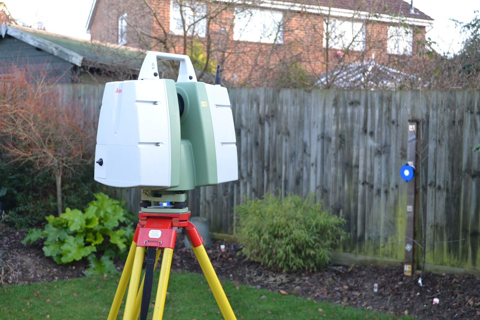
Leica C10 Laser Scanner
So why bother with it now as it is unlikely to provide us with a cost saving now? And how do we create this base model to build up from?

Well the basics lie in the Surveyors ability to create a 3D model of a site, something from a topographical stand point we have been doing for years but from a building stand point we are now having to utilise new technology to produce the required level of detail. As a general rule all buildings are surveyed in 3D and then flattened onto a 2D plane once back at the office, this is certainly true for laser scanning which can be used to create a fully referenced point cloud of a building, both inside and out. The real issue is down to cost, as Surveyors we can create the 3D model, but generally the client is only willing to pay for the 2D, when in reality the 3D has a far greater long term benefit.

Pure Point Cloud Data
Point Cloud Rendered in true colour
Laser scanning technology allows a massive amount of data to be collected in 3D in a very short space of time.  The images below show the results of two thirty minute scans, and about five minutes work in the processing software.  The first is a raw point cloud with rendering based on the intensity of the signal being received back from the surface being scanned.  The second image is the same raw point cloud but the colour from the photographs taken by the taken has been superimposed onto each point for a realistic impression of the site.  The next step from here to create the BIM model would be to mesh all of your scans (both internal and external) together and render the flat surfaces to remove the excess point data.  The results hopefully would be something similar to that shown below.


How far can we take you?


As Land Surveyors we can create the template of your existing building in a raw format, and given time we can develop our training to include the production of the bare bones model.  From this point on it is down to the Project Managers , and then the Estates team to develop this model to include the various functions it has the potential to record such as :-  

  • Catalogues of all the light fittings, including replacement dates, suppliers details, costs
  • Position & alignment of all cabling and pipes, again with their suppliers and replacement dates
  • Basic room details and layouts
The potential is endless, but the on going maintenance of the system is essential.  Without constant up dating the system will soon become redundant and the whole process will need to be repeated at a much higher cost.  However keeping the system maintained will provide massive time savings when sourcing replacement parts, or even fabricating new elements into an existing system.

Want to know more?


  1. The BIM task group have been set up by the Government to ensure delivery of the Construction Strategy.  
  2. BIM UK is a central resource containing all references for best practices for incorporating BIM.  
  3. Building.co.uk is a leading construction website covering all elements of the construction industry including BIM.


The last word...


Like it or loathe it BIM is coming and we will all be racing to keep pace with this development which has been common practice in some of our European neighbours for some years.


R L Surveys are Chartered Land Surveyors based in London & the south east.  For more details of the services we offer please visit us at www.rlsurveys.co.uk, alternatively we can be followed on Twitter Facebook  & LinkedIn.


Friday, 4 January 2013

2012 a distant memory?

That's all folks, 2012 has been put to bed and 2013 is just rubbing its eyes and working out what to do next.  Sadly for 2013 it has a big act to follow in 2012, but it can but try.

Whilst it is always nice to look back at the past, and revel in past success (or dwell on past failures) the only benefit is to learn and move forward, in this case, into 2013.  This year will bring around some exciting changes for R L Surveys in many ways, being our second full trading year we can look forward to:-


  1. A increased presence in the boundaries market.  With a Chartered Surveyor on board we are now able to work through boundary disputes under guidelines laid down by RICS, the industries governing body, as well as push the other areas of boundaries such as demarcation & first registration.
  2. With a new toy in the cupboard we are looking forward to providing a complete measured building survey services.  The final investment of 2012 was a Leica C10 laser scanner, the capabilities of which can be found on our website, or through this brief Youtube video (Thank you Paul Burrows of Leica).  This new piece of kit enables our Surveyors to carry out site surveys in a fraction of the time previously with a large element of safety, and a much much greater coverage of data.
  3. Completion of our accreditation to ISO9001 which will give our customers peace of mind about the product we produce.
  4. With these new developments we will need to expand our workforce to service the ever growing demands on our time, so again keep an eye on our website for the vacancies as they appear.
With those thoughts in mind it just leaves me to wish you all a Happy and Prosperous New Year.  Lets raise a glass to whats to come in 2013.